| Aracar | |
|---|---|
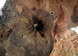
 Aracar from the Space Shuttle, January 2003 | |
| Highest point | |
| Elevation | 6,095 m (19,997 ft)[1][a] |
| Prominence | 1,791 m (5,876 ft)[6][7] |
| Parent peak | Ojos del Salado |
| Listing | Ultra |
| Coordinates | 24°17′24″S 67°47′00″W / 24.29000°S 67.78333°W[6] |
| Geography | |
| Parent range | Andes |
| Geology | |
| Rock age | Pliocene |
| Mountain type | Stratovolcano |
| Last eruption | 1993[8] |
| Climbing | |
| First ascent | 04/01/1958 - Yosko Cvitanic (Yugoslavia), Gustav Lanstchner and Emo Henrich (Austria)[9][10] |
Aracar is a large conical stratovolcano in northwestern Argentina, just east of the Chilean border. It has a main summit crater about 1–1.5 kilometres (0.6–0.9 mi) in diameter which sometimes contains crater lakes, and a secondary crater. The volcano has formed, starting during the Pliocene, on top of a lava platform and an older basement. Constructed on a base with an altitude of 4,100 metres (13,500 ft), it covers a surface area of 192.4 square kilometres (74.3 sq mi) and has a volume of 148 cubic kilometres (36 cu mi). The only observed volcanic activity was a possible steam or ash plume on March 28, 1993, seen from the village of Tolar Grande about 50 km (31 mi) southeast of the volcano, but with no evidence of deformation of the volcano from satellite observations. Inca archeological sites are found on the volcano.
- ^ Cite error: The named reference
Cerutiwas invoked but never defined (see the help page). - ^ USGS, EROS Archive. "USGS EROS Archive - Digital Elevation - SRTM Coverage Maps". Retrieved 12 April 2020.
- ^ "ASTER GDEM Project". ssl.jspacesystems.or.jp. Retrieved 2020-04-14.
- ^ TanDEM-X, TerraSAR-X. "Copernicus Space Component Data Access". Archived from the original on 12 April 2020. Retrieved 12 April 2020.
- ^ "Aracar". Andes Specialists. Retrieved 2020-04-12.
- ^ a b "Argentina and Chile North: Ultra-Prominences" Peaklist.org. Retrieved 2013-02-25.
- ^ "Aracar". Andes Specialists. Retrieved 2020-04-12.
- ^ Cite error: The named reference
GVPwas invoked but never defined (see the help page). - ^ Milenco Jurcich. Arqueologia de las Cumbres. pp. 23–24.
- ^ "AAJ (American Alpine Journal)". AAJ (American Alpine Journal): 314. 1959.
Cite error: There are <ref group=lower-alpha> tags or {{efn}} templates on this page, but the references will not show without a {{reflist|group=lower-alpha}} template or {{notelist}} template (see the help page).
