Arai
新居町 | |
|---|---|
Former municipality | |
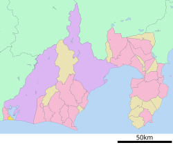
 Location of Arai in Shizuoka Prefecture | |
| Coordinates: 34°41′N 137°34′E / 34.683°N 137.567°E | |
| Country | Japan |
| Region | Chūbu (Tōkai) |
| Prefecture | Shizuoka Prefecture |
| District | Hamana |
| Merged | March 23, 2010 (now part of Kosai) |
| Area | |
| • Total | 18.65 km2 (7.20 sq mi) |
| Population (March 31, 2010) | |
| • Total | 16,975 |
| • Density | 910/km2 (2,400/sq mi) |
| Time zone | UTC+09:00 (JST) |
| Symbols | |
| Bird | Barn swallow |
| Flower | Azalea |
| Tree | Japanese black pine |
Arai (新居町, Arai-chō) was a town located in Hamana District, Shizuoka Prefecture, Japan.
As of March 31, 2010, the town had an estimated population of 16,975 and a population density of 910 persons per km2. The total area was 18.65 km2.
On March 23, 2010, Arai was merged into the expanded city of Kosai and thus no longer exists as an independent municipality. Hamana District was dissolved as a result of this merger.[1]
- ^ "市町村合併情報 静岡県 <国土地理協会>". Archived from the original on 2007-07-28. Retrieved 2008-09-08.


