| Arakan Mountains | |
|---|---|
| Rakhine Mountains | |
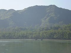
 View of the Arakan Mountains in Maungdaw district rising above the banks of the Naf River | |
| Highest point | |
| Peak | Mount Victoria |
| Elevation | 3,094 m (10,151 ft) |
| Coordinates | 21°25′46.36″N 93°49′10.75″E / 21.4295444°N 93.8196528°E |
| Naming | |
| Native name | ရခိုင်ရိုးမ (Burmese) |
| Geography | |
| Country | Myanmar |
| State | Rakhine State |
| Range coordinates | 21°16′N 93°57′E / 21.267°N 93.950°E |
| Geology | |
| Rock type(s) | metamorphic and tightly folded sedimentary rocks over crystalline basement |
The Arakan Mountains, natively referred as Rakhine Yoma (Burmese: ရခိုင်ရိုးမ) and technically known as the Southern Indo-Burman Range, are a mountain range in western Myanmar, between the coast of Rakhine State and the Central Myanmar Basin, in which flows the Irrawaddy River. It is the most prominent of a series of parallel ridges that arc through Assam, Nagaland, Manipur, Mizoram and Myanmar.
The Arakan Mountains run from Cape Negrais in the south in to Manipur, India in the north. They include the Naga Hills, the Chin Hills, and the Patkai range which includes the Lushai Hills.[1] The mountain chain is submerged in the Bay of Bengal for a long stretch and emerges again in the form of the Andaman and Nicobar Islands.
- ^ "Rakhine Mountains". Encyclopædia Britannica. Retrieved 9 Nov 2013.
