Arcabuco | |
|---|---|
Municipality and town | |
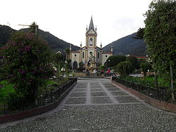
 Central square and church of Arcabuco | |
 Location of the municipality and town of Arcabuco in the Boyacá Department of Colombia | |
| Country | |
| Department | Boyacá Department |
| Province | Ricaurte Province |
| Founded | 22 October 1856 |
| Founded by | Celedonio Umaña and Leopoldo Rodríguez |
| Government | |
| • Mayor | Yamith Rodrigo Rodriguez Lopez (2020–2023) |
| Area | |
| • Municipality and town | 155 km2 (60 sq mi) |
| • Urban | 35 km2 (14 sq mi) |
| Elevation | 2,739 m (8,986 ft) |
| Population (2015) | |
| • Municipality and town | 5,240 |
| • Urban | 1,961 |
| Time zone | UTC-5 (Colombia Standard Time) |
| Website | Official website |
Arcabuco is a town and municipality in the Ricaurte Province, part of the Colombian Department of Boyacá. Arcabuco is situated on the Altiplano Cundiboyacense with the urban centre at an altitude of 2,739 metres (8,986 ft). The municipality borders Moniquirá and Gámbita in the north, Villa de Leyva and Chíquiza in the south, Cómbita in the east and Gachantivá and Villa de Leyva in the west. The department capital Tunja is 34 kilometres (21 mi) to the south.[1]
- ^ (in Spanish) Official website Arcabuco
