| Arches National Park | |
|---|---|
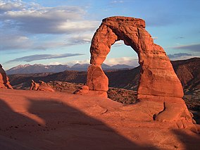
 Delicate Arch with background of La Sal Mountains | |
| Location | Grand County, Utah, US |
| Nearest city | Moab, Utah |
| Coordinates | 38°43′41″N 109°32′24″W / 38.72806°N 109.54000°W |
| Area | 76,679 acres (119.811 sq mi; 31,031 ha; 310.31 km2)[1] |
| Established | April 12, 1929, as a national monument |
| Visitors | 1,460,652 (in 2022)[2] |
| Governing body | National Park Service |
| Website | nps |
Arches National Park is a national park of the United States in eastern Utah. The park is adjacent to the Colorado River, 4 mi (6 km) north of Moab, Utah. The park contains more than 2,000 natural sandstone arches, including the well-known Delicate Arch, which constitute the highest density of natural arches in the world. It also contains a variety of other unique geological resources and formations.[3][4] The national park lies above an underground evaporite layer or salt bed, which is the main cause of the formation of the arches, spires, balanced rocks, sandstone fins, and eroded monoliths in the area.
The park consists of 310.31 km2 (76,680 acres; 119.81 sq mi; 31,031 ha) of high desert located on the Colorado Plateau.[5] The highest elevation in the park is 5,653 ft (1,723 m) at Elephant Butte, and the lowest elevation is 4,085 ft (1,245 m) at the visitor center. The park receives an average of less than 10 in (250 mm) of rain annually.
Administered by the National Park Service, the area was originally named a national monument on April 12, 1929, and was redesignated as a national park on November 12, 1971.[6] The park received more than 1.8 million visitors in 2021.[2] From April 1 through October 31, a timed entry reservation is required to visit the park between the hours of 7 a.m. and 4 p.m.[7]
- ^ "Listing of acreage – December 31, 2011" (XLSX). Land Resource Division, National Park Service. Retrieved 2012-03-05. (National Park Service Acreage Reports)
- ^ a b "NPS Annual Recreation Visits Report". National Park Service. Retrieved 2023-07-25.
- ^ Rowan, James. "Arches National Park". YC.edu. Yavasai College. Archived from the original on 22 August 2021. Retrieved 7 September 2016.
- ^ "Nature". NPS.gov. National Park Service. Archived from the original on 7 December 2021. Retrieved 7 September 2016.
- ^ "Arches National Park". nationalgeographic.com. 5 November 2009. Archived from the original on 5 October 2013. Retrieved 2 October 2013.
- ^ "Arches National Park". The National Parks: Index 2009–2011. National Park Service. Archived from the original on 29 June 2011. Retrieved 2011-06-08.
- ^ "Timed Entry Pilot - Arches National Park (U.S. National Park Service)". Archived from the original on 2023-04-04. Retrieved 2023-04-05.

