Argalasti
Αργαλαστή | |
|---|---|
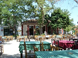
 Argalasti square 2007 | |
| Coordinates: 39°14′N 23°13′E / 39.233°N 23.217°E | |
| Country | Greece |
| Administrative region | Thessaly |
| Regional unit | Magnesia |
| Municipality | South Pelion |
| Area | |
| • Municipal unit | 74.8 km2 (28.9 sq mi) |
| Elevation | 196 m (643 ft) |
| Population (2021)[1] | |
| • Municipal unit | 1,603 |
| • Municipal unit density | 21/km2 (56/sq mi) |
| • Community | 1,395 |
| Time zone | UTC+2 (EET) |
| • Summer (DST) | UTC+3 (EEST) |
| Postal code | 370 06 |
| Area code(s) | 24230 |
| Vehicle registration | ΒΟ |
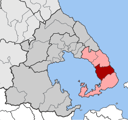
Argalasti (Greek: Αργαλαστή) is a village and a former municipality in Magnesia, Thessaly, Greece. Since the 2011 local government reform it is part of the municipality South Pelion, of which it is the seat and a municipal unit.[2] The municipal unit has an area of 74.820 km2.[3] It is built on a fertile plateau, 40 km southeast of Volos. It is an important commercial and tourism center of the area with a rich cultural tradition. Argalasti is a stopping point for those headed for the nearby beaches of the Pagasetic Gulf (Chorto, Kalamos, Lefokastro) or the Aegean Sea (Potistika, Melani, Paltsi). An example of the architecture of the beginning of the 20th century is the church tower of Sts. Apostles.
- ^ "Αποτελέσματα Απογραφής Πληθυσμού - Κατοικιών 2021, Μόνιμος Πληθυσμός κατά οικισμό" [Results of the 2021 Population - Housing Census, Permanent population by settlement] (in Greek). Hellenic Statistical Authority. 29 March 2024.
- ^ "ΦΕΚ B 1292/2010, Kallikratis reform municipalities" (in Greek). Government Gazette.
- ^ "Population & housing census 2001 (incl. area and average elevation)" (PDF) (in Greek). National Statistical Service of Greece. Archived (PDF) from the original on 2015-09-21.

