This article needs additional citations for verification. (May 2008) |
Arghandab District
ارغنداب | |
|---|---|
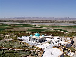
 The Shrine of Baba Wali in the Arghandab district. | |
| Coordinates: 31°39′17″N 65°38′58″E / 31.65472°N 65.64944°E | |
| Country | |
| Province | Kandahar Province |
| Center | Town of Arghandab |
| Elevation | 1,112 m (3,648 ft) |
| Population (2006) | |
| • Total | 54,900 |
| Time zone | + 4.30 |
| Website | Arghandab.gov |
Arghandab (Pashto/Persian: ارغنداب) is a district in the central part of Kandahar Province, Afghanistan.[1] It borders Panjwai and Khakrez districts to the west, Shah Wali Kot District to the north and east and Kandahar District to the east and south.[2]
The population, as of 2006, was 54,900. The district centre is Arghandab, located northwest of Kandahar. The Arghandab River flows through the district in its eastern part West from the district center, and the area is irrigated by the Helmand and Arghandab Valley Authority.[3][4] The climate, river and irrigation allow the inhabitants to aggregate several different forms of produce. The main agricultural crops in this region are pomegranates, grapes, plums, and Cannabis sativa.

- ^ Johnson, Thomas H.; Adamec, Ludwig W. (2021-05-15). Historical Dictionary of Afghanistan. Rowman & Littlefield. ISBN 978-1-5381-4929-4.
- ^ Trousdale, William B. (2021-03-08). Kandahar in the Nineteenth Century. BRILL. ISBN 978-90-04-44522-2.
- ^ (pdf) The Helmand Valley Project in Afghanistan: A.I.D. Evaluation Special Study No. 18 C Clapp-Wicek & E Baldwin, U.S. Agency for International Development, published December 1983
- ^ Zentner, Matthew (2011-10-13). Design and impact of water treaties: Managing climate change. Springer Science & Business Media. ISBN 978-3-642-23743-0.
