This article needs additional citations for verification. (June 2013) |
Bottom: The Delta Cultural Center in Helena-West Helena is operated by the Department of Arkansas Heritage to preserve and interpret the culture of the region.
| Part of a series on |
| Regions of Arkansas |
|---|
 |
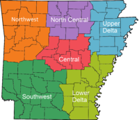
The Arkansas Delta is one of the six natural regions of the state of Arkansas. Willard B. Gatewood Jr., author of The Arkansas Delta: Land of Paradox, says that rich cotton lands of the Arkansas Delta make that area "The Deepest of the Deep South."[1]
The region runs along the Mississippi River from Eudora north to Blytheville and as far west as Little Rock. It is part of the Mississippi embayment, itself part of the Mississippi River Alluvial Plain.[2] The flat plain is bisected by Crowley's Ridge, a narrow band of rolling hills rising 250 to 500 feet (76 to 152 m) above the flat delta plains. Several towns and cities have been developed along Crowley's Ridge, including Jonesboro.[3] The region's lower western border follows the Arkansas River just outside Little Rock down through Pine Bluff. There the border shifts to Bayou Bartholomew, stretching south to the Arkansas-Louisiana state line.
While the Arkansas Delta shares many geographic similarities with the Mississippi Delta, it is distinguished by its five unique sub-regions: the St. Francis Basin, Crowley's Ridge, the White River Lowlands, the Grand Prairie and the Arkansas River Lowlands (also called "the Delta Lowlands"). Much of the region is within the Mississippi lowland forests ecoregion.
The Arkansas Delta includes the entire territories of 15 counties: Arkansas, Chicot, Clay, Craighead, Crittenden, Cross, Desha, Drew, Greene, Lee, Mississippi, Monroe, Phillips, Poinsett, and St. Francis.[4] It also includes portions of another 10 counties: Jackson, Lawrence, Prairie, Randolph, White, Pulaski, Lincoln, Jefferson, Lonoke and Woodruff counties.[5]
- ^ Williard B. Gatewood Jr. and Jeannie M. Whayne, ed. (1996). The Arkansas Delta: Land of Paradox. University of Arkansas Press. p. 3. ISBN 978-1-61075-032-5.
- ^ Gatewood and Whayne 1993, p. 3.
- ^ Smith, Richard M. (1989). The Atlas of Arkansas. The University of Arkansas Press. p. 19. ISBN 1557280479.
- ^ "The Arkansas Delta - The Region". Arkansas Delta Byways. Archived from the original on November 8, 2010. Retrieved July 31, 2012.
- ^ Gatewood and Whayne (1993), N.Pag.

