| Aroostook River | |
|---|---|
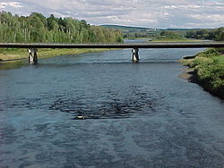
 Aroostook River at Washburn, Maine | |
 Aroostook River watershed | |
| Location | |
| Country | United States, Canada |
| State | Maine |
| Province | New Brunswick |
| Cities | Ashland, Maine, Washburn, Maine, Presque Isle, Maine, Caribou, Maine, Fort Farfield, Maine |
| Physical characteristics | |
| Source confluence | Millinocket Stream and Munsungan Stream |
| • location | Maine Township 8, Range 8, WELS, Penobscot County, Maine |
| • coordinates | 46°20′40″N 68°48′04″W / 46.3445°N 68.8011°W |
| Mouth | Saint John River (New Brunswick) |
• location | Aroostook, NB |
• coordinates | 46°48′36″N 67°42′58″W / 46.810123°N 67.71620°W |
• elevation | 330 ft (100 m) |
| Length | 112 mi (180 km) |
| Basin size | 2,442.7 sq mi (6,327 km2) |
| Discharge | |
| • location | Masardis, Maine |
| • average | 1,506 cu ft/s (42.6 m3/s) |
| • minimum | 41 cu ft/s (1.2 m3/s) |
| • maximum | 29,500 cu ft/s (840 m3/s) |
| Discharge | |
| • location | Washburn, Maine |
| • average | 2,696 cu ft/s (76.3 m3/s) |
| • minimum | 75 cu ft/s (2.1 m3/s) |
| • maximum | 49,500 cu ft/s (1,400 m3/s) |
| Watershed data.[1] | |
The Aroostook River is a 112-mile-long (180 km)[2] tributary of the Saint John River in the U.S. state of Maine and the Canadian province of New Brunswick. Its basin is the largest sub-drainage of the Saint John River.[3]
The name is derived from the Malecite name Wool-ahs-took, translated by Ganong as "good river for everything". It appears as Arassatuk (DeRozier, 1699).[4]
- ^ University of Maine. "Watershed Overview and Data Access: Aroostook." Watershed Code 01010004. Accessed 2010-02-17.
- ^ U.S. Geological Survey. National Hydrography Dataset high-resolution flowline data. The National Map Archived 2012-03-29 at the Wayback Machine, accessed June 22, 2011
- ^ Gibbs, K. Elizabeth; Bradeen, Billie; Boland, Dan (September 2004). "Spatial and Temporal Segregation Among Six Species of Coexisting Ophiogomphus (Odonata: Gomphidae) in the Aroostook River, Maine". Northeastern Naturalist. 11 (3): 295–312. doi:10.1656/1092-6194(2004)011[0295:SATSAS]2.0.CO;2. ISSN 1938-5307. JSTOR 3858420.
- ^ Hamilton, William (1978). The Macmillan Book of Canadian Place Names. Toronto: Macmillan. p. 70. ISBN 0-7715-9754-1.