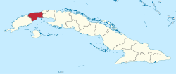
Artemisa Province | |
|---|---|
 | |
| Coordinates: 22°48′49″N 82°45′48″W / 22.81361°N 82.76333°W | |
| Country | Cuba |
| Capital | Artemisa |
| Municipalities | Mariel, Guanajay, Caimito, Bauta, San Antonio de los Baños, Güira de Melena, Alquízar, Artemisa, Candelaria, San Cristóbal, Bahía Honda |
| Government | |
| • President | Ricardo Concepción Rodríguez |
| Area | |
| • Total | 4,004.27 km2 (1,546.06 sq mi) |
| Highest elevation | 681 m (2,234 ft) |
| Population (2010-12-31)[1] | |
| • Total | 502,312 |
| • Density | 130/km2 (320/sq mi) |
| Time zone | UTC-5 (EST) |
| Area code | +53-47 |
| HDI (2019) | 0.797[2] high · 3rd of 16 |
| Website | https://www.artemisa.gob.cu/es/ |
Artemisa Province is one of the two new provinces created from the former La Habana Province, whose creation was approved by the Cuban National Assembly on August 1, 2010, the other being Mayabeque Province.[3][4][5] The new provinces came into existence on January 1, 2011.
- ^ a b "Lugar que ocupa el territorio según la superficie y la población" (PDF). Una MIRADA a Cuba (in Spanish). Oficina Nacional de Estadísticas. Cuba. 2010. Archived from the original (PDF) on 2019-03-11. Retrieved 2012-01-15.
- ^ "Sub-national HDI - Area Database - Global Data Lab". hdi.globaldatalab.org. Retrieved 2018-09-13.
- ^ La racionalidad como premisa Archived 2010-06-11 at the Wayback Machine - Periódico Granma
- ^ Proponen en Pleno del Partido dos nuevas provincias cubanas: Artemisa y Mayabeque (+ Infografía) - Cubadebate
- ^ ¿Por qué Artemisa y Mayabeque?[permanent dead link]