Asaminami-ku, Hiroshima
広島市安佐南区 | |
|---|---|
Ward of Hiroshima | |
| 安佐南区• Asaminami-ku | |
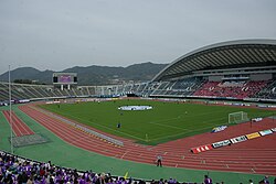
 Hiroshima Big Arch | |
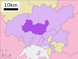
 Location of Mihama in Asaminami-ku in Hiroshima City | |
| Coordinates: 34°27′07″N 132°28′19″E / 34.45194°N 132.47194°E | |
| Country | Japan |
| Region | Chūgoku (Sanyo) |
| Prefecture | Hiroshima |
| City | Hiroshima |
| Area | |
| • Total | 117.24 km2 (45.27 sq mi) |
| Population | |
| • Total | 245,475 |
| • Density | 2,094/km2 (5,420/sq mi) |
| Time zone | UTC+9 (Japan Standard Time) |
| Postal | 731-0193 |
| Asaminami Ward Office's Address | Furuichi 1-33-14, Asaminami-ku, Hiroshima City, Hiroshima Prefecture (広島県広島市安佐南区古市1丁目33番14号) |
| Phone | 81-(0)82-831-4925, 831-4927 |
Asaminami-ku (安佐南区) is one of the eight wards of the city of Hiroshima, located in the south of former Asa District.
Asa District consisted of Gion-cho, Yasufuruichi-cho, Sato-cho, Numata-cho. After being merged with Hiroshima in 1973, this ward was named Asaminami-ku. The largest station of Astramline, a new traffic system, is in Asaminami-ku. This system brought population inflow.[citation needed]
As of January 1, 2018, the ward has an estimated population of 245,475, with 101,941 households and a density of 2094 persons per km2. The total area is 117.24 km2.[2][1]
- ^ a b "広島市 - 面積" (in Japanese). Hiroshima City. Archived from the original on April 26, 2017. Retrieved February 5, 2018.
- ^ a b "広島市 - 推計人口" (in Japanese). Hiroshima City. Archived from the original on February 6, 2018. Retrieved February 5, 2018.
Cite error: There are <ref group=lower-alpha> tags or {{efn}} templates on this page, but the references will not show without a {{reflist|group=lower-alpha}} template or {{notelist}} template (see the help page).

