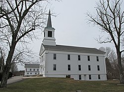
Ashaway, Rhode Island | |
|---|---|
CDP | |
 First Seventh Day Baptist Church of Hopkinton | |
| Coordinates: 41°25′23″N 71°47′20″W / 41.42306°N 71.78889°W | |
| State | Rhode Island |
| County | Washington |
| Area | |
| • Total | 2.42 sq mi (6.26 km2) |
| • Land | 2.37 sq mi (6.15 km2) |
| • Water | 0.04 sq mi (0.11 km2) |
| Elevation | 62 ft (19 m) |
| Population | |
| • Total | 1,501 |
| • Density | 632.27/sq mi (244.11/km2) |
| Time zone | UTC−5 (Eastern (EST)) |
| • Summer (DST) | UTC−4 (EDT) |
| ZIP Code | 02804 |
| Area code | 401 |
| FIPS code | 44-03520[3] |
| GNIS feature ID | 1217657[4] |
Ashaway (/ˈæʃəweɪ/) is an unincorporated village and census-designated place (CDP) in the town of Hopkinton, Rhode Island, United States. It is a principal village of Hopkinton, along with Hope Valley, although it is the smaller of the two. The population was 1,485 at the 2010 census. The name Ashaway is derived from the American Indian name for the river that runs through the village, the Ashawague or Ashawaug, which means "land in the middle" or "land between" in the Niantic and Mohegan languages.[5] The name "Ashawague River" appears as late as 1832 on the Findley map of Rhode Island published in Philadelphia.
- ^ "ArcGIS REST Services Directory". United States Census Bureau. Retrieved October 12, 2022.
- ^ "Census Population API". United States Census Bureau. Retrieved October 12, 2022.
- ^ "U.S. Census website". United States Census Bureau. Retrieved January 31, 2008.
- ^ "US Board on Geographic Names". United States Geological Survey. October 25, 2007. Retrieved January 31, 2008.
- ^ "Indian place names of New England". New York: Museum of the American Indian, Heye Foundation. 1962.
