Ashland | |
|---|---|
 Ashland community marker painted on I-238 overpass at Mission Blvd | |
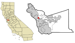
 Location in Alameda County and the state of California | |
| Coordinates: 37°41′41″N 122°06′50″W / 37.69472°N 122.11389°W | |
| Country | |
| State | |
| County | Alameda |
| Government | |
| • Type | Unincorporated community |
| • State Senate | Aisha Wahab (D)[1] |
| • State Assembly | Liz Ortega (D)[2] |
| • U. S. Congress | Eric Swalwell (D)[3] |
| • District 4 Alameda County Supervisor | Nate Miley |
| Area | |
| • Total | 1.84 sq mi (4.77 km2) |
| • Land | 1.84 sq mi (4.77 km2) |
| • Water | 0.00 sq mi (0.00 km2) 0% |
| Elevation | 43 ft (13 m) |
| Population (2020) | |
| • Total | 23,823 |
| • Density | 12,926.21/sq mi (4,992.00/km2) |
| Time zone | UTC-8 (Pacific (PST)) |
| • Summer (DST) | UTC-7 (PDT) |
| ZIP code | 94541, 94578, 94580 |
| Area codes | 510, 341 |
| FIPS code | 06-02980 |
| GNIS feature IDs | 1657955, 2407773 |
Ashland is a census-designated place (CDP) and unincorporated community[6] in Alameda County, California, United States. The population was 23,823 at the 2020 census.[7] Ashland is located between the city of San Leandro to the north, the unincorporated community of Cherryland to the south, the unincorporated community of Castro Valley to the east, and the unincorporated community of San Lorenzo to the southwest.
Ashland shares a postal zip code with the neighboring unincorporated community of San Lorenzo to the southwest, as well as the close by cities of Hayward to the south and San Leandro to the north. Ashland has been informally, albeit incorrectly, known as "unincorporated San Leandro" or "unincorporated Hayward" due to Ashland not having its own postal zip code designation.
- ^ "Senators". State of California. Retrieved March 18, 2013.
- ^ "Members Assembly". State of California. Retrieved March 18, 2013.
- ^ "California's 14th Congressional District - Representatives & District Map". Civic Impulse, LLC. Retrieved March 9, 2013.
- ^ "2020 U.S. Gazetteer Files". United States Census Bureau. Retrieved October 30, 2021.
- ^ "Ashland". Geographic Names Information System. United States Geological Survey, United States Department of the Interior.
- ^ Community Locator. Alameda County http://communitylocator.acgov.org/. Retrieved February 12, 2021.
{{cite web}}: Missing or empty|title=(help) - ^ "U.S. Census Bureau QuickFacts: Ashland CDP, California". United States Census Bureau. Retrieved September 26, 2021.
