| Askja | |
|---|---|
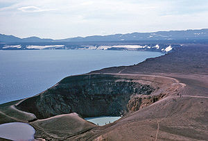
 Askja caldera in 1984 | |
| Highest point | |
| Elevation | 1,516 m (4,974 ft)[1] |
| Listing | Volcanoes of Iceland |
| Coordinates | 65°01′59″N 16°46′59″W / 65.033°N 16.783°W[2] |
| Geography | |
| Parent range | Dyngjufjöll |
| Geology | |
| Mountain type | caldera |
| Last eruption | October to December 1961[2] |
 Geological features near the Dyngjufjöll (Askja) central volcano and Askja volcanic system (red outlines). Other shading shows: calderas, central volcanoes and fissure swarms, subglacial terrain above 1,100 m (3,600 ft), and seismically active areas. Clicking on the image enlarges to full window and enables mouse-over with more detail. | |


Askja ([ˈasca] ) is an active volcano situated in a remote part of the central highlands of Iceland. The name Askja refers to a complex of nested calderas within the surrounding Dyngjufjöll [ˈtiɲcʏˌfjœtl̥] mountains, which rise to 1,514 m (4,967 ft), askja meaning box or caldera in Icelandic.[3]
- ^ "Topographic map of Askja". opentopomap.org. Retrieved 2023-06-15.
- ^ a b "Askja". Global Volcanism Program. Smithsonian Institution. Retrieved 2024-06-26.
- ^ See e.g.: Stóra Tölvuorðabókin. Úfgáfa 6.0
