| Aspley | |
|---|---|
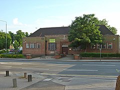
 Aspley Library | |
Location within Nottinghamshire | |
| Population | 17,622 (Ward 2011) |
| OS grid reference | SK 53645 42405 |
| Unitary authority | |
| Ceremonial county | |
| Region | |
| Country | England |
| Sovereign state | United Kingdom |
| Post town | NOTTINGHAM |
| Postcode district | NG8 |
| Police | Nottinghamshire |
| Fire | Nottinghamshire |
| Ambulance | East Midlands |
| UK Parliament | |
Aspley is a council estate and a ward of the city of Nottingham, Nottinghamshire, England. It is located within the boundaries of Nottingham City Council. The ward is located 3 miles (4.8 km) west of Nottingham City Centre and is located only 1.6 miles west of Junction 26 of the M1. It lies south of Bulwell, west of Basford and is north of Bilborough. The principal road in the ward is the A610. At the 2001 Census the ward had a population of 15,689, increasing to 17,622 at the 2011 census.[1]
For a number of centuries the ward consisted of just a number of small settlements and was home to both Broxtowe and Aspley Hall, the latter home to the Willoughby family for a number of generations. In the early 20th century Nottingham City Council, after a number of purchase orders developed the area into a large housing estate.
The ward contains three housing estates which consist of Aspley, Broxtowe (not to be confused with the borough Broxtowe) and Bells Lane estate. Aspley has a number of shops, a local library and transport links (by bus) with Nottingham City Centre and surrounding areas.
- ^ "City of Nottingham Ward population 2011". Neighbourhood Statistics. Office for National Statistics.
