 Aerial view of Assateague Island with Ocean City, Maryland in the background | |
| Geography | |
|---|---|
| Location | Atlantic Ocean |
| Coordinates | 37°58′35.07″N 75°18′17.12″W / 37.9764083°N 75.3047556°W |
| Area | 63 km2 (24 sq mi) |
| Administration | |
United States | |
| Additional information | |
| Official website | |


Assateague Island is a 37-mile (60 km) long barrier island located off the eastern coast of the Delmarva Peninsula facing the Atlantic Ocean.[1] The northern two-thirds of the island are in Maryland, and the southern third is in Virginia.
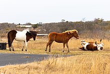
The Maryland section contains the majority of Assateague Island National Seashore and Assateague State Park. The Virginia section contains Chincoteague National Wildlife Refuge and a one-mile stretch of land containing the lifeguarded recreational beach and interpretive facilities managed by the National Park Service (or NPS).[2] It is best known for its herds of feral horses, pristine beaches, and the Assateague Lighthouse. The island also contains numerous marshes, bays, and coves, including Toms Cove.[3] Bridge access for cars is possible from both Maryland and Virginia, though no road runs the full north/south length of the island.
- ^ Kenney, Nathaniel T. "Watermen's Island Home", National Geographic, Index (January–June 1980), vol 157 (June 1980): 812.
- ^ Turner, John and Jay Kirkpatrick. Field Guide to the Assateague Ponies. Toledo, Ohio 1988.
- ^ GMCO Maps & Charts. GMCO's Fishing & Recreation Map of Chincoteague-Assateague, Virginia, 2003.


