| Assunpink Creek | |
|---|---|
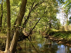
 View west along the Assunpink Creek in West Windsor, NJ | |
 | |
| Location | |
| Country | United States |
| State | New Jersey |
| Region | Monmouth County, Mercer County |
| Physical characteristics | |
| Source | |
| • location | Millstone Township |
| • coordinates | 40°12′8″N 74°26′24″W / 40.20222°N 74.44000°W |
| • elevation | 240 ft (73 m) |
| Mouth | Delaware River |
• location | Trenton |
• coordinates | 40°12′59″N 74°46′12″W / 40.21639°N 74.77000°W |
• elevation | 3 ft (0.91 m) |
| Basin features | |
| River system | Delaware River |
| Tributaries | |
| • left | New Sharon Branch, Miry Run |
| • right | Bridegroom Run, Shabakunk Creek |
Assunpink Creek is a 22.9-mile-long (36.9 km)[1] tributary of the Delaware River in western New Jersey in the United States.[2] The name Assunpink is from the Lenape Ahsën'pink, meaning "stony, watery place".
- ^ U.S. Geological Survey. National Hydrography Dataset high-resolution flowline data. The National Map Archived 2012-03-29 at the Wayback Machine, accessed April 1, 2011
- ^ Gertler, Edward. Garden State Canoeing, Seneca Press, 2002. ISBN 0-9605908-8-9