Aurangabad district | |
|---|---|
| Chhatrapati Sambhaji Nagar district | |
From top, left to right: Kailasha temple at the Ellora Caves; facade of Ajanta Cave 19; Buddha carvings to the right of Cave 19's entrance; Bibi Ka Maqbara; Tomb of Aurangzeb, Khuldabad; Daulatabad Fort | |
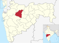
 Location in Maharashtra | |
| Country | |
| State | Maharashtra |
| Division | Aurangabad |
| Headquarters | Aurangabad |
| Tehsils | |
| Government | |
| • Body | Aurangabad Zilla Parishad |
| • Guardian Minister | Abdul Sattar Additional charge (Cabinet Minister) |
| • President Zilla Parishad |
|
| • District collector | Deelip Swami (IAS) |
| • CEO Zilla Parishad | Nilesh R. Gatne (IAS) |
| • MPs | |
| Area | |
| • Total | 10,100 km2 (3,900 sq mi) |
| Population (2011) | |
| • Total | 3,701,282 |
| • Density | 370/km2 (950/sq mi) |
| • Urban | 37.53% |
| Demographics | |
| • Literacy | 79.02% |
| • Sex ratio | 924 |
| Time zone | UTC+05:30 (IST) |
| Vehicle registration | MH-20 |
| Major highways | NH-211 |
| Official Language | Marathi |
| Per capita income(Aurangabad district) | INR 1,63,325(2019–20)[1] |
| Nominal gross domestic product(Aurangabad district) | INR 74,738crores (2019–20)[2] |
| Website | aurangabad |
Aurangabad district (Marathi pronunciation: [əu̯ɾəŋɡaːbaːd̪]),[3] officially known as Chhatrapati Sambhaji Nagar district,[4][5] is one of the 36 districts of the state of Maharashtra in western India. It borders the districts of Nashik to the west, Jalgaon to the north, Jalna to the east, and Ahmednagar to the south. The city of Aurangabad houses the district's administrative headquarters. The district has an area of 10,100 km2, of which 37.55% is urban and the rest is rural. Aurangabad District is a major tourism region in Marathwada, with attractions including the Ajanta Caves and Ellora Caves.
- ^ Records, Official. "Per capita income of district of Maharashtra 2019-20". economy Department, Government of Maharashtra, India. Maharashtra Vidhanmanda. Archived from the original on 8 August 2022. Retrieved 29 June 2022.
- ^ Records, Official. "nominal gross district Domestic Product of Maharashtra 2019-20". economy Department, Government of Maharashtra, India. Maharashtra Vidhanmanda. Archived from the original on 8 August 2022. Retrieved 29 June 2022.
- ^ Urdu pronunciation:[ɔːɾəŋɡaːbaːd̪]
- ^ Malik, Faisal (16 September 2023). "Aurangabad formally renamed Chhatrapati Sambhajinagar, Osmanabad as Dharashiv". Hindustan Times. Retrieved 8 September 2024.
- ^ Gokhale, Omkar (9 May 2024). "In relief to Maharashtra govt, Bombay HC dismisses pleas against renaming of Aurangabad, Osmanabad cities and districts". The Indian Express. Retrieved 8 September 2024.


