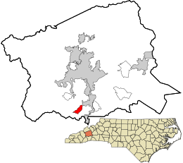
Avery Creek, North Carolina | |
|---|---|
 Location in Buncombe County and the state of North Carolina | |
| Coordinates: 35°27′54″N 82°34′19″W / 35.46500°N 82.57194°W | |
| Country | United States |
| State | North Carolina |
| County | Buncombe |
| Area | |
• Total | 1.73 sq mi (4.49 km2) |
| • Land | 1.73 sq mi (4.49 km2) |
| • Water | 0.00 sq mi (0.00 km2) |
| Elevation | 2,231 ft (680 m) |
| Population (2020) | |
• Total | 2,241 |
| • Density | 1,293.88/sq mi (499.66/km2) |
| Time zone | UTC-5 (Eastern (EST)) |
| • Summer (DST) | UTC-4 (EDT) |
| ZIP code | 28704[3] |
| Area code | 828 |
| FIPS code | 37-02760[4] |
| GNIS feature ID | 2402655[2] |
Avery Creek is a census-designated place (CDP) in Buncombe County, North Carolina, United States. The population was 1,950 at the 2010 census.[5] It is part of the Asheville Metropolitan Statistical Area.
- ^ "ArcGIS REST Services Directory". United States Census Bureau. Retrieved September 20, 2022.
- ^ a b U.S. Geological Survey Geographic Names Information System: Avery Creek, North Carolina
- ^ "Avery Creek ZIP Code". zipdatamaps.com. 2023. Retrieved January 12, 2023.
- ^ "U.S. Census website". United States Census Bureau. Retrieved January 31, 2008.
- ^ "Geographic Identifiers: 2010 Demographic Profile Data (G001): Avery Creek CDP, North Carolina". U.S. Census Bureau, American Factfinder. Archived from the original on February 12, 2020. Retrieved February 13, 2014.