Ayodhya district
Faizabad district | |
|---|---|
Clockwise from top-left: Diwali at Ram ki Paidi, Bahu Begum ka Maqbara, Amsin Bazar, Saryu river near Ayodhya, Gulab Bari | |
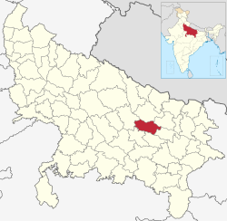
 Location of Ayodhya district in Uttar Pradesh | |
| Country | |
| State | Uttar Pradesh |
| Division | Ayodhya |
| Headquarters | Ayodhya |
| Tehsils | 5 |
| Government | |
| • Lok Sabha constituencies |
|
| • Vidhan Sabha constituencies | |
| Area | |
• Total | 2,522 km2 (974 sq mi) |
| Population | |
• Total | 2,470,996 |
| • Density | 980/km2 (2,500/sq mi) |
| • Urban | 689,354 |
| Demographics | |
| • Literacy | 69.57% |
| • Sex ratio | 961 |
| Time zone | UTC+05:30 (IST) |
| Vehicle registration | UP-42 |
| Major highways | NH 27, NH 330, NH 330A, SH 30 |
| Website | ayodhya |
Ayodhya district (previously known as Faizabad district) is one of the 75 districts in the northern Indian state of Uttar Pradesh. The city of Ayodhya is its administrative headquarters.[1][3] The district occupies an area of 2,522 square kilometres (974 sq mi),[1] and had a population of 2,470,996 in the 2011 census.[1][2] Ayodhya district shares its borders with 6 districts of Uttar Pradesh. It is bordered by Gonda and Basti districts on the northern side, Amethi and Sultanpur districts on the south, and Ambedkar Nagar and Barabanki districts share the border on the east and west.
The official name of the district was changed from Faizabad to Ayodhya in November 2018.[4]
- ^ a b c d e "About district". District Ayodhya, Government of Uttar Pradesh. Retrieved 27 July 2021.
- ^ a b "Census of India: Search Details – Faizabad District". www.censusindia.gov.in. Retrieved 6 November 2019.
- ^ Tully, Mark (2017), India in Slow Motion, Penguin Random House India Private Limited, pp. 18–, ISBN 978-93-5118-097-5
- ^ "Faizabad district to be renamed as Ayodhya, says UP CM Yogi Adityanath". The Financial Express. 6 November 2018. Retrieved 9 November 2019.


