Azusa, California
Asuksa-nga | |
|---|---|
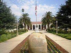
 Azusa City Hall | |
| Nickname: "The Canyon City" | |
 Location of Azusa in Los Angeles County, California | |
| Coordinates: 34°7′50″N 117°54′25″W / 34.13056°N 117.90694°W | |
| Country | United States |
| State | California |
| County | Los Angeles |
| Founded | 1887[1] |
| Incorporated | December 29, 1898[2] |
| Incorporated | August 14, 1901[3] |
| Named for | A hispanicized version of Asuksa-nga, the Tongva settlement that existed at the time of Spanish colonization |
| Government | |
| • Type | Council-Manager |
| • Mayor | Robert Gonzales[4] |
| • Mayor Pro Tem | Dennis Beckwith[4] |
| • Councilmember | Edward J. Alvarez[4] |
| • Councilmember | Andrew N. Mendez[4] |
| • Councilmember | Jesse Avila Jr.[4] |
| Area | |
| • Total | 9.67 sq mi (25.05 km2) |
| • Land | 9.66 sq mi (25.02 km2) |
| • Water | 0.01 sq mi (0.03 km2) 0.13% |
| Elevation | 610 ft (186 m) |
| Population (2020) | |
| • Total | 50,000 |
| • Density | 5,175.45/sq mi (1,998.24/km2) |
| Time zone | UTC−8 (Pacific) |
| • Summer (DST) | UTC−7 (PDT) |
| ZIP Code | 91702 |
| Area code | 626 |
| FIPS code | 06-03386 |
| GNIS feature IDs | 1652667, 2409768 |
| Website | azusaca |
Azusa (Tongva: Asuksa-nga)[7] is a city in the San Gabriel Valley region of Los Angeles County, California, United States, at the foot of the San Gabriel Mountains and located 20 miles (32 km) east of downtown Los Angeles.
Its population was 50,000 in 2020, an increase from 46,361 at the 2010 census.[8] Azusa is located along historic Route 66, which passes through the city on Foothill Boulevard and Alosta Avenue.
Azusa is bordered by the San Gabriel Mountains range to the north, Irwindale to the west, the unincorporated community of Vincent to the southwest, Glendora and the unincorporated community of Citrus to the east, and Covina to the south.
- ^ "Azusa History". Azusa, CA. Retrieved March 13, 2015.
- ^ "California Cities by Incorporation Date". California Association of Local Agency Formation Commissions. Archived from the original (Word) on November 3, 2014. Retrieved August 25, 2014.
- ^ "California Cities by Incorporation Date". California Association of Local Agency Formation Commissions. Archived from the original (Word) on November 3, 2014. Retrieved August 25, 2014.
- ^ a b c d e "City Council". Azusa, CA. Retrieved October 20, 2014.
- ^ "2020 U.S. Gazetteer Files". United States Census Bureau. Retrieved October 30, 2021.
- ^ "Azusa". Geographic Names Information System. United States Geological Survey, United States Department of the Interior. Retrieved March 13, 2015.
- ^ City of Azusa - History
- ^ "U.S. Census Bureau QuickFacts: Azusa city, California". Census.gov. Retrieved July 19, 2022.


