This article needs additional citations for verification. (November 2011) |
Native name: Kepulauan Babar | |
|---|---|
 Babar Islands in the south of the Maluku Islands | |
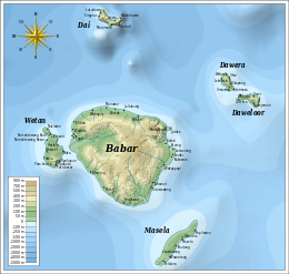
 Map of the Babar Islands. | |
| Geography | |
| Location | Southeast Asia |
| Archipelago | Maluku Islands |
| Administration | |
| Province | Maluku |
| Additional information | |
| Time zone | |
The Babar Islands (Indonesian: Kepulauan Babar) are located in Maluku Province, Indonesia between latitudes 7 degrees 31 minutes South to 8 degrees 13 minutes South and from longitudes 129 degrees 30 minutes East to 130 degrees 05 minutes East. The group now constitutes five districts (kecamatan) within the Maluku Barat Daya Regency of Maluku province.
Tepa (a town with a population of about 2,000 people) is the administrative center of the former Babar Islands district ("Kecamatan Pulau-Pulau Babar") now reduced to encompass only the western half of Babar Island together with Dai Island (to the north of Babar), and renamed Babar Barat ("West Babar") District. Wetang Island (lying to the west of Babar) now forms a separate district. The town of Letwurung on the east side of Babar island is the capital of the district formerly called "East Babar" ("Kecamatan Pulau-Pulau Babar Timor") in the east half of the Babar Islands, consisting of the East half of Babar Island, and now simply renamed Babar Timur (East Babar) District. Masela Island (to the south-east of Babar) forms a separate district, as do the islands of Dawelor and Dawera (to the east). The archipelago covers a land area of 759.37 km2 and had 17,406 inhabitants at the 2010 Census, but the official estimate as at mid 2023 was 20,586.[1]
The Babar Islands are part of the Banda Sea Islands moist deciduous forests ecoregion.
- ^ Badan Pusat Statistik, Jakarta, 2023.