Native name: ᕿᑭᖅᑖᓗᒃ (Qikiqtaaluk) | |
|---|---|
 | |
 | |
| Geography | |
| Location | Northern Canada |
| Coordinates | 68°N 70°W / 68°N 70°W[1] |
| Archipelago | Arctic Archipelago |
| Area | 507,451 km2 (195,928 sq mi) |
| Area rank | 5th |
| Highest elevation | 2,147 m (7044 ft) |
| Highest point | Mount Odin |
| Administration | |
Canada | |
| Territory | Nunavut |
| Largest settlement | Iqaluit (pop. 7,429[2]) |
| Demographics | |
| Population | 13,039[2][3] (2021) |
| Pop. density | 0.03/km2 (0.08/sq mi) |
| Ethnic groups | Inuit (72.7%), non-Aboriginal (25.3%), First Nations (0.7%), Métis (0.5%)[4] |
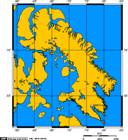
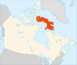
Baffin Island (formerly Baffin Land),[5] in the Canadian territory of Nunavut, is the largest island in Canada, the second-largest island in the Americas (behind Greenland), and the fifth-largest island in the world. Its area is 507,451 km2 (195,928 sq mi) with a population density of 0.03/km2; the population was 13,039 according to the 2021 Canadian census;[2] and it is located at 68°N 70°W / 68°N 70°W[1]. It also contains the city of Iqaluit (with a population of around 7,000), which is the capital of Nunavut.
- ^ a b "Baffin Island". Geographical Names Data Base. Natural Resources Canada.
- ^ a b c Cite error: The named reference
2021censusNUwas invoked but never defined (see the help page). - ^ Does not include Kinngait (1,396) and Qikiqtarjuaq (593). Both of which do not lie on Baffin Island proper
- ^ 2006 Aboriginal Population Profile for Nunavut communities.
- ^ Baffin Island / Île de Baffin (Formerly Baffin Land)

