| Bagnell Dam | |
|---|---|
 Bagnell Dam | |
| Country | United States |
| Location | 617 River Road, Lakeside, Missouri |
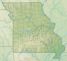
| Coordinates | 38°12′08″N 92°37′37″W / 38.20222°N 92.62694°W |
| Purpose | Hydroelectric |
| Construction began | 1929 |
| Opening date | 1931 |
| Owner(s) | Ameren |
| Dam and spillways | |
| Type of dam | Concrete gravity |
| Impounds | Osage River |
| Height (foundation) | 148 ft (45 m)[1] |
| Length | 2,543 ft (775 m)[1] |
| Spillway type | Gated overflow[1] |
| Reservoir | |
| Creates | Lake of the Ozarks |
| Total capacity | 1,927,000 acre⋅ft (2.377 km3)[2] |
| Active capacity | 468,000 acre⋅ft (0.577 km3)[3] |
| Catchment area | 13,944 sq mi (36,110 km2)[3] |
| Surface area | 54,000 acres (22,000 ha)[3] |
| Normal elevation | 660 ft (200 m) max[3] |
| Osage Powerplant | |
| Type | Conventional |
| Hydraulic head | 90 ft (27 m)[3] |
| Turbines | Main: 8x 21.5 MW (33,500 HP) Francis[1] Station service: 2x 2.0 MW (3,025 HP) Francis[3] |
| Installed capacity | 176.0 MW[1] 220 MW (overload)[3] |
| Annual generation | 624,000 MWh[4] |
Bagnell Dam and Osage Power Plant | |
| Area | 6 acres (2.4 ha) |
| Architect | Stone & Webster |
| Architectural style | Gravity Dam |
| NRHP reference No. | 08000822[5] |
| Added to NRHP | August 27, 2008 |
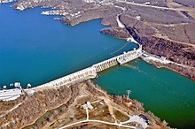
Bagnell Dam (informally, the Osage Dam[6]) impounds the Osage River in the U.S. state of Missouri, creating the Lake of the Ozarks. The dam is located in the city of Lakeside in Miller County, near the Camden-Miller County line. The 148-foot (45 m) tall concrete gravity dam was built by the Union Electric Company (now Ameren) to generate hydroelectric power at its Osage Powerplant. It is 2,543 feet (775 m) long, including a 520-foot (160 m) long spillway and a 511-foot (156 m) long power station. The facility with eight generators has a maximum capacity of 215 megawatts. The dam provides power to 42,000 homes.[7]
The dam also creates Bagnell Dam Boulevard (formerly US 54 prior to 1968[8], then formally US 54 Business Route), a narrow two-lane highway connecting the nearby Bagnell Dam Strip with Lakeland and US 54. The dam is named for the nearby town of Bagnell, Missouri, which was named for William Bagnell, who platted the town in 1883.[9]
- ^ a b c d e "Bagnell Dam Facts and Figures". The Lake Area History Pages. Retrieved 2016-02-24.
- ^ "Hydrology". Missouri Department of Conservation. Archived from the original on 2016-01-31. Retrieved 2016-02-24.
- ^ a b c d e f g White, R. Gail (2010). "Bagnell Dam and Osage Power Plant, Osage Plant Power Station" (PDF). Historic American Engineering Record. Washington, D.C.: Library of Congress. Retrieved February 17, 2021.
- ^ Ingram, Elizabeth (6 September 2018). "Dam safety improvement work completed at Bagnell Dam in U.S." Hydro World. Retrieved 20 May 2019.
- ^ "National Register Information System". National Register of Historic Places. National Park Service. July 9, 2010.
- ^ U.S. Geological Survey Geographic Names Information System: Bagnell Dam
- ^ Bechtold, Nathan (January 10, 2017). "Huge Bagnell Dam Project To Add 66 Million Pounds Of Concrete". The Lake Expo. Retrieved July 7, 2021.
- ^ 1969 Missouri Highway Map (Map). Retrieved August 16, 2020.
- ^ The Story Of Bagnell

