Bahawalnagar
ضلع بہاولنگر | |
|---|---|
Top: Marot Fort Bottom: Fields in Chak 38-R | |
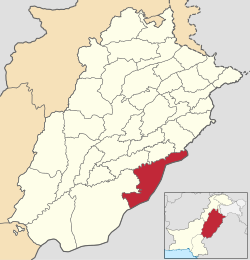
 Map of Bahawalnagar District (highlighted in red) within Punjab. | |
| Country | |
| Province | |
| Division | Bahawalpur |
| Headquarters | Bahawalnagar |
| Government | |
| • Type | District Administration |
| • Deputy Commissioner | Muhammad Waseem |
| • District Police Officer | Muhammad Essa Khan Sukhera |
| Area | |
| • District of Punjab | 8,878 km2 (3,428 sq mi) |
| Population | |
| • District of Punjab | 3,550,342 |
| • Density | 400/km2 (1,000/sq mi) |
| • Urban | 974,118 |
| • Rural | 2,576,224 |
| Literacy | |
| • Literacy rate |
|
| Time zone | UTC+5 (PKT) |
| Area code | 063 |
| No. of Tehsils | 5 |
| Tehsils | Bahawalnagar Chishtian Fort Abbas Haroonabad Minchinabad |
| Website | bahawalnagar |
Bahawalnagar District (Urdu and Punjabi: ضلع بہاولنگر), is a district of Punjab province in Pakistan. Before the independence of Pakistan, Bahawalnagar was part of Bahawalpur state governed by the Nawab of Bahawalpur. The city of Bahawalnagar is the capital of the district.[3]
- ^ Cite error: The named reference
2023censuswas invoked but never defined (see the help page). - ^ "Literacy rate, enrolments, and out-of-school population by sex and rural/urban, CENSUS-2023" (PDF).
- ^ "Bahawalnagar District - population per 2017 Census of Pakistan (scroll down to page 8 of 16 for Bahawalnagar District)" (PDF). Pakistan Bureau of Statistics, Government of Pakistan website. Archived from the original (PDF) on 7 November 2017. Retrieved 14 December 2023.

