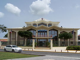
Baie-Mahault | |
|---|---|
 The town hall of Baie-Mahault | |
 Location of the commune (in red) within Guadeloupe | |
| Coordinates: 16°16′N 61°35′W / 16.27°N 61.58°W | |
| Country | France |
| Overseas region and department | Guadeloupe |
| Arrondissement | Basse-Terre |
| Canton | Baie-Mahault-1 and 2 |
| Intercommunality | CAP Excellence |
| Government | |
| • Mayor (2020–2026) | Hélène Polifonte Molia[1] |
| Area 1 | 46.00 km2 (17.76 sq mi) |
| Population (2021)[2] | 30,909 |
| • Density | 670/km2 (1,700/sq mi) |
| Time zone | UTC−04:00 (AST) |
| INSEE/Postal code | 97103 /97122 |
| Elevation | 0–112 m (0–367 ft) |
| Website | www |
| 1 French Land Register data, which excludes lakes, ponds, glaciers > 1 km2 (0.386 sq mi or 247 acres) and river estuaries. | |
Baie-Mahault (French pronunciation: [bɛ ma.o]; Guadeloupean Creole: Bémao) is a commune in the overseas department and region of Guadeloupe, France.[3] It is the second most populated commune of Guadeloupe, after Les Abymes. The extensive industrial zone of Jarry in Baie-Mahault is by far the most industrialized commune in the islands and the largest industrial park in the Lesser Antilles. It is part of the urban area of Pointe-à-Pitre, the largest metropolitan area in Guadeloupe, located in the northwest.
The inhabitants of Baie-Mahault are called Baie-Mahaultiens.
- ^ "Répertoire national des élus: les maires" (in French). data.gouv.fr, Plateforme ouverte des données publiques françaises. 13 September 2022.
- ^ "Populations légales 2021" (in French). The National Institute of Statistics and Economic Studies. 28 December 2023.
- ^ Commune de Baie-Mahault (97103), INSEE

