Baker, California | |
|---|---|
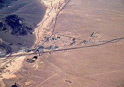
 Aerial view of Baker looking north: I-15 jogs south around the town, leaving Baker Boulevard, the main street, to show where the pre-interstate highway (US 91 and US 466) went. Baker Airport sits just north of the city alongside northbound CA 127, the "Death Valley Road". | |
 Location in San Bernardino County and the state of California | |
| Coordinates: 35°16′33″N 116°03′57″W / 35.27583°N 116.06583°W | |
| Country | |
| State | |
| County | San Bernardino |
| Area | |
| • Total | 2.69 sq mi (6.96 km2) |
| • Land | 2.69 sq mi (6.96 km2) |
| • Water | 0.00 sq mi (0.00 km2) 0% |
| Elevation | 942 ft (287 m) |
| Population (2020) | |
| • Total | 442 |
| • Density | 164.43/sq mi (63.49/km2) |
| Time zone | UTC-8 (Pacific) |
| • Summer (DST) | UTC-7 (PDT) |
| ZIP codes | 92309 |
| Area codes | 442/760 |
| FIPS code | 06-03512 |
| GNIS feature IDs | 238894, 2628708 |
| U.S. Geological Survey Geographic Names Information System: Baker, California | |

Baker is a census-designated place located in San Bernardino County, California, US.[2] As of the 2010 census, the CDP had a total population of 735. Baker's ZIP Code is 92309 and the community is within area codes 442 and 760.
- ^ "2020 U.S. Gazetteer Files". United States Census Bureau. Retrieved October 30, 2021.
- ^ a b "Baker Census Designated Place". Geographic Names Information System. United States Geological Survey, United States Department of the Interior. Retrieved April 8, 2015.

