Baker City | |
|---|---|
 Main Street | |
| Motto: "On the Historic Oregon Trail." | |
 Location in Oregon | |
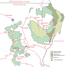
 Baker City along I-84 in Oregon, surrounded by sections of Wallowa–Whitman National Forest. | |
| Coordinates: 44°46′30″N 117°49′55″W / 44.77500°N 117.83194°W | |
| Country | United States |
| State | Oregon |
| County | Baker |
| Platted | 1865[1] |
| Incorporated | 1874[1] |
| Area | |
| • Total | 7.16 sq mi (18.55 km2) |
| • Land | 7.16 sq mi (18.55 km2) |
| • Water | 0.00 sq mi (0.00 km2) |
| Elevation | 3,451 ft (1,052 m) |
| Population | |
| • Total | 10,099 |
| • Density | 1,410.08/sq mi (544.40/km2) |
| Time zone | UTC−08:00 (Pacific) |
| • Summer (DST) | UTC−07:00 (Pacific) |
| ZIP Code | 97814 |
| Area code | 541 |
| FIPS code | 41-03650 |
| GNIS feature ID | 2409773[3] |
| Website | Official website |
Baker City is a city in and the county seat of Baker County, Oregon, United States. It was named after Edward Dickinson Baker, the only U.S. Senator ever killed in military combat. The population was 10,099 at the time of the 2020 census.
- ^ a b Cite error: The named reference
bluebookwas invoked but never defined (see the help page). - ^ "ArcGIS REST Services Directory". United States Census Bureau. Retrieved October 12, 2022.
- ^ a b U.S. Geological Survey Geographic Names Information System: Baker City, Oregon
- ^ Cite error: The named reference
USCensusDecennial2020CenPopScriptOnlywas invoked but never defined (see the help page).


