| Baker River | |
|---|---|
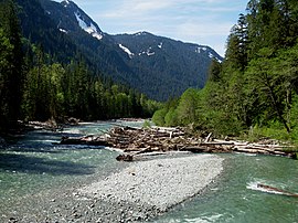
 Baker River upstream of Baker Lake | |
 Map of the Baker River watershed | |
Location of the mouth of Baker River in Washington | |
| Location | |
| Country | United States |
| State | Washington |
| County | Skagit, Whatcom |
| Physical characteristics | |
| Source | Cascade Range |
| • location | Whatcom Peak, Whatcom County |
| • coordinates | 48°51′1″N 121°22′52″W / 48.85028°N 121.38111°W[1] |
| • elevation | 5,800 ft (1,800 m) |
| Mouth | Skagit River |
• location | Concrete, Skagit County |
• coordinates | 48°45′54″N 121°32′34″W / 48.76500°N 121.54278°W[1] |
• elevation | 820 ft (250 m)[1] |
| Length | 30 mi (48 km)[1] |
| Basin size | 297 sq mi (770 km2)[2] |
| Discharge | |
| • location | river mile 0.7 near Concrete, WA[2] |
| • average | 2,649 cu ft/s (75.0 m3/s)[2] |
| • minimum | 30 cu ft/s (0.85 m3/s) |
| • maximum | 36,600 cu ft/s (1,040 m3/s) |
The Baker River (Lushootseed: dxʷqəlb)[3] is an approximately 30-mile (48 km),[1] southward-flowing tributary of the Skagit River in northwestern Washington in the United States. It drains an area of the high North Cascades in the watershed of Puget Sound north of Seattle, and east of Mount Baker. With a watershed of approximately 270 square miles (700 km2) in a complex of deep valleys partially inside North Cascades National Park, it is the last major tributary of the Skagit before the larger river reaches its mouth on Skagit Bay. The river flows through Concrete, Washington, near its mouth and has two hydroelectric dams owned by Puget Sound Energy.
- ^ a b c d e "Baker River". Geographic Names Information System. United States Geological Survey, United States Department of the Interior.
- ^ a b c "Water Resources Data-Washington Water Year 2005; Skagit River Basin; 12193500 Baker River at Concrete, WA" (PDF). United States Geological Survey. Retrieved 2009-05-31.
- ^ Bates, Dawn; Hess, Thom; Hilbert, Vi (1994). Lushootseed Dictionary. Seattle: University of Washington Press. p. 85. ISBN 978-0-295-97323-4. OCLC 29877333.
