Balcarres | |
|---|---|
Town | |
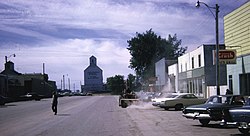
 Balcarres Main Street in 1968 | |
Location of Balcarres in Saskatchewan | |
| Coordinates: 50°48′00″N 103°32′40″W / 50.80000°N 103.54444°W | |
| Country | Canada |
| Province | Saskatchewan |
| Rural Municipalities (R.M.) | Abernethy No. 186 |
| Post Office founded NWT | 1884-04-01 |
| Government | |
| • Mayor | Dwight Dixon |
| • Administrator | Bev Gelech |
| • Governing body | Balcarres Town Council |
| Area | |
| • Total | 1.57 km2 (0.61 sq mi) |
| Population (2011) | |
| • Total | 617 |
| • Density | 392.9/km2 (1,018/sq mi) |
| Time zone | UTC−6 |
| • Summer (DST) | CST |
| Postal code | S0G 0C0 |
| Area code | 306 |
| Highways | Highway 10 Highway 22 Highway 619 Highway 310 |
| Website | Town of Balcarres |
| [1][2][3][4][5] | |
Balcarres (/bəlˈkɛərrɪs/ bel-KAIR-is);[6] 2006 population 598) is a town located in southern Saskatchewan, Canada along Highway 10 and Highway 22, approximately 85 kilometres (53 mi) northeast of Regina. Highways 619 and 310 are nearby highways to this community. The town is about 15 kilometres (9.3 mi) northeast of the Fishing Lakes.
Neighbouring communities include Fort Qu'Appelle to the west, to the southeast Abernethy, and to the north Ituna. The File Hills First Nations of Little Black Bear, Peepeekisis, Okanese, and Star Blanket are also located to the northeast.
- ^ "2011 Community Profiles". Statistics Canada. Government of Canada. Archived from the original on 26 December 2018. Retrieved 20 March 2014.
- ^ National Archives, Archivia Net. "Post Offices and Postmasters". Archived from the original on 6 October 2006. Retrieved 20 March 2014.
- ^ Government of Saskatchewan, MRD Home. "Municipal Directory System". Archived from the original on 15 January 2016. Retrieved 20 March 2014.
- ^ Canadian Textiles Institute (2005), CTI Determine your provincial constituency, archived from the original on 11 September 2007
- ^ Commissioner of Canada Elections, Chief Electoral Officer of Canada (2005), Elections Canada On-line, archived from the original on 21 April 2007
- ^ The Canadian Press (2017), The Canadian Press Stylebook (18th ed.), Toronto: The Canadian Press
