Balkhash-Alakol Basin
Балқаш-Алакөл ойысы Балхаш-Алакольская котловина | |
|---|---|
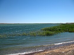
 View of the shores of Lake Balkhash, the main waterbody of the basin | |
| Coordinates: 46°0′N 77°30′E / 46.000°N 77.500°E | |
| Location | Kazakhstan |
| Part of | Karaganda Region, Zhambyl Region, Almaty Region and East Kazakhstan Region |
| Area | |
| • Total | ca 22,000 km2 (8,500 sq mi) |
| Dimensions | |
| • Length | 700 km (430 mi) |
| • Width | 100 km (62 mi) to 300 km (190 mi) |
| Elevation | 342 m (1,122 ft) to 600 m (2,000 ft) |
The Balkhash-Alakol Basin[1] or Balkhash-Alakol Depression[2](Kazakh: Балқаш-Алакөл ойысы; Russian: Балхаш-Алакольская котловина), is a flat structural basin in southeastern Kazakhstan.[3][4]
The basin is named after lakes Balkhash and Alakol, the largest waterbodies in the trough. The main city in the area is Balkhash.[5][6][4]
- ^ Changes in glaciation of the Balkhash–Alakol basin, central Asia, over recent decades
- ^ Sala, Renato; Deom, Jean-Marc; Aladin, Nikolai V.; Plotnikov, Igor S.; Nurtazin, Sabyr (2020). "Geological History and Present Conditions of Lake Balkhash". Large Asian Lakes in a Changing World. Springer Water. pp. 143–175. doi:10.1007/978-3-030-42254-7_5. ISBN 978-3-030-42253-0.
- ^ Балхаш-Алакольская котловина; Great Soviet Encyclopedia in 30 vols. — Ch. ed. A.M. Prokhorov. - 3rd ed. - M. Soviet Encyclopedia, 1969-1978. (in Russian)
- ^ a b Google Earth
- ^ "L-43 Topographic Chart (in Russian)". Retrieved 27 September 2022.
- ^ "L-44 Topographic Chart (in Russian)". Retrieved 27 September 2022.
