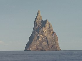
 Ball's Pyramid seen from the surrounding waters | |
 Ball's Pyramid is to the southeast of Lord Howe Island | |
| Geography | |
|---|---|
| Location | Pacific Ocean |
| Coordinates | 31°45′15″S 159°15′06″E / 31.75417°S 159.25167°E |
| Length | 1,100 m (3600 ft) |
| Width | 300 m (1000 ft) |
| Highest elevation | 572 m (1877 ft)[1] |
| Administration | |
| State | New South Wales |
Ball's Pyramid is an uninhabited islet in the Pacific Ocean located 20 kilometres (12 mi) southeast of Lord Howe Island. The steep rocky basalt outcrop is the eroded plug of a shield volcano and caldera that formed 6.4 million years ago.[2][3] It is 572 metres (1,877 ft) high, while measuring 1,100 metres (3,609 ft) in length and only 300 metres (984 ft) across, making it the tallest volcanic stack in the world.[4]
Ball's Pyramid, which is part of Australia's Lord Howe Island Marine Park, is positioned in the centre of a submarine shelf surrounded by rough seas, which makes any approach difficult.[2]
- ^ "Ball's Pyramid". Peakbagger. Retrieved 17 March 2023.
- ^ a b Woodroffe, Colin (29 May 2012). "Balls Pyramid and the efficacy of marine abrasion". Vignettes. Carleton College. Retrieved 9 July 2013.
- ^ Woodroffe, Colin. "Balls Pyramid and the efficacy of marine abrasion". Vignettes: Key Concepts in Geomorphology. Carleton College. Retrieved 28 June 2023.
- ^ "Geography and Geology". Lord Howe Island Tourism Association. Archived from the original on 12 September 2014. Retrieved 20 April 2009.
