Ball, Louisiana | |
|---|---|
Town | |
| Town of Ball | |
 Welcome sign for Ball (established 1972) | |
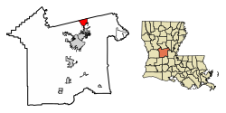
 Location of Ball in Rapides Parish, Louisiana. | |
 Location of Louisiana in the United States | |
| Coordinates: 31°24′29″N 92°24′08″W / 31.40806°N 92.40222°W | |
| Country | United States |
| State | Louisiana |
| Parish | Rapides |
| Incorporated | May 1972 |
| Government | |
| Area | |
| • Total | 7.95 sq mi (20.59 km2) |
| • Land | 7.95 sq mi (20.59 km2) |
| • Water | 0.00 sq mi (0.00 km2) |
| Elevation | 161 ft (49 m) |
| Population (2020) | |
| • Total | 3,961 |
| • Rank | RA: 3rd |
| • Density | 498.18/sq mi (192.34/km2) |
| Time zone | UTC-6 (CST) |
| • Summer (DST) | UTC-5 (CDT) |
| ZIP code | 71405[2] |
| Area code | 318 |
| FIPS code | 22-04055 |
| Website | http://www.ball.govoffice2.com/ |

Ball is a town in Rapides Parish, just north of Pineville, Louisiana, United States. Established in 1972, it is part of the Alexandria, Louisiana Metropolitan Statistical Area. The population was 4,000 at the 2010 census, an increase of 8.7 percent over the 2000 tabulation of 3,681.
- ^ "2020 U.S. Gazetteer Files". United States Census Bureau. Retrieved March 20, 2022.
- ^ "Ball LA ZIP Code". zipdatamaps.com. 2023. Retrieved June 16, 2023.