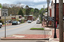
Ball Ground, Georgia | |
|---|---|
 Ball Ground Historic District | |
 Location in Cherokee County and the state of Georgia | |
| Coordinates: 34°20′19″N 84°22′39″W / 34.33861°N 84.37750°W | |
| Country | United States |
| State | Georgia |
| County | Cherokee |
| Government | |
| • Mayor | A.R. “Rick” Roberts, III |
| Area | |
| • Total | 6.35 sq mi (16.44 km2) |
| • Land | 6.31 sq mi (16.34 km2) |
| • Water | 0.04 sq mi (0.09 km2) |
| Elevation | 1,102 ft (336 m) |
| Population (2020) | |
| • Total | 2,560 |
| • Density | 405.71/sq mi (156.63/km2) |
| Time zone | UTC-5 (Eastern (EST)) |
| • Summer (DST) | UTC-4 (EDT) |
| ZIP code | 30107 |
| Area codes | 770/678/470 |
| FIPS code | 13-05036[2] |
| GNIS feature ID | 0354443[3] |
| Website | cityofballground |
Ball Ground is a city in Cherokee County, Georgia, United States. The city was originally Cherokee territory before they were removed from the land and it was given to white settlers. A railroad was built in 1882 and a town was formed around the resulting railroad stop. The town was incorporated on January 1, 1883, and became an industrial-based economy largely centered around its marble industry until around the mid-20th century when the industries began to leave and the city started to decline. From 2000 onwards the city saw rapid growth; as of the 2020 census the city had a population of 2,560, which is over three times the city's population of 730 in 2000.
- ^ "2020 U.S. Gazetteer Files". United States Census Bureau. Archived from the original on March 18, 2021. Retrieved December 18, 2021.
- ^ "U.S. Census website". United States Census Bureau. Archived from the original on December 27, 1996. Retrieved January 31, 2008.
- ^ "US Board on Geographic Names". United States Geological Survey. October 25, 2007. Archived from the original on December 25, 2018. Retrieved January 31, 2008.
- ^ "Ball Ground". GeorgiaGov. Archived from the original on September 22, 2012. Retrieved September 6, 2012.


