| Ballarat East Ballarat, Victoria | |||||||||||||||
|---|---|---|---|---|---|---|---|---|---|---|---|---|---|---|---|
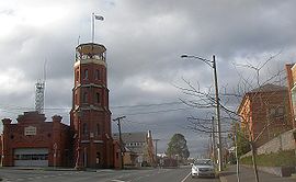
 Former East Ballarat Civic Area on the corner of Barkly and East Streets. The Ballarat Fire Station is on the left, the old library and Ballarat Secondary College are on the right. | |||||||||||||||
 | |||||||||||||||
| Coordinates | 37°33′48″S 143°52′08″E / 37.5632°S 143.869°E | ||||||||||||||
| Population | 5,937 (2021 census)[1] | ||||||||||||||
| Postcode(s) | 3350 | ||||||||||||||
| Location | 3 km (2 mi) from Ballarat Central | ||||||||||||||
| LGA(s) | City of Ballarat | ||||||||||||||
| State electorate(s) | Eureka | ||||||||||||||
| Federal division(s) | Ballarat | ||||||||||||||
| |||||||||||||||
Ballarat East is a suburb of Ballarat in Victoria, Australia. From 1857 until 1921 the suburb had its own council (see below). The suburb covers a large area east of the city centre. It is the oldest urban area in Ballarat and was the site of many goldmines, as well as of the Eureka Rebellion.
The population of Ballarat East at the 2021 census was 5,937, making it the fourth most populated suburb in the Ballarat area.[1] The former town retains much of its shambolic character, particularly its winding and unplanned streets which arose organically among the many gold mines.[2] Much of the suburb is subject to heritage protection because of its local historical significance, with many dwellings dating from the 1860s to the 1940s.
- ^ a b Australian Bureau of Statistics (28 June 2022). "Ballarat East (State Suburb)". 2021 Census QuickStats. Retrieved 3 November 2022.
- ^ Bate, W. Life after gold: twentieth century Ballarat. Carlton, Melbourne University Press, 1993.
