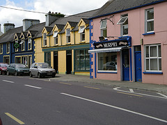
Ballineen and Enniskean
Béal Átha Fhínín / Inis Céin Ballineen and Enniskeane | |
|---|---|
Twin village | |
 Main Street Ballineen | |
| Coordinates: 51°44′8″N 8°56′55″W / 51.73556°N 8.94861°W | |
| Country | Ireland |
| Province | Munster |
| County | County Cork |
| Population | 692 |
| Time zone | UTC+0 (WET) |
| • Summer (DST) | UTC-1 (IST (WEST)) |
The twin villages of Ballineen (Irish: Béal Átha Fhínín, meaning 'mouth of Fineen's ford')[2] and Enniskeane,[3][4] or Enniskean, (Irish: Inis Céin, meaning 'island of Cian')[5][6] in County Cork in Ireland are 43 km (26.72 mi) southwest of Cork City, on the R586 road. The linear settlement lies on the River Bandon between Bandon and Dunmanway.[4] The combined settlement is designated as a 'key village' by Cork County Council for planning purposes and,[4] as of the 2016 census, had a population of 692 people.[1]
- ^ a b "Census 2016 Sapmap Area: Settlements Ballineen-Enniskean". census.cso.ie. Central Statistics Office. April 2016. Archived from the original on 26 July 2020.
- ^ "Béal Átha Fhínín / Ballineen". logainm.ie. Placenames Database of Ireland. Retrieved 29 April 2023.
- ^ Cork County Council (19 July 2022). "Mayor, Cllr. Danny Collins Officially opens the Ballineen and Enniskeane Community Walkway". Cork County Council. Retrieved 13 May 2023.
- ^ a b c "Dunmanway Integrated Development Strategy 2007" (PDF). Dunmanway Inter-Agency Committee. Retrieved 6 May 2023 – via communityplanningtoolkit.org.
- ^ "The Twin Villages of Ballineen and Enniskean". ballineenandenniskean.weebly.com. Retrieved 12 August 2020.
- ^ "Inis Céin / Enniskean". logainm.ie. Placenames Database of Ireland. Retrieved 29 April 2023.
