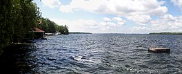
| Balsam Lake | |
|---|---|
 | |
| Location | Kawartha Lakes, Ontario |
| Group | Kawartha Lakes |
| Coordinates | 44°34′50″N 78°50′30″W / 44.58056°N 78.84167°W[1] |
| Primary inflows | Gull River, Staples River, Corben Creek |
| Primary outflows | Rosedale River, Trent Canal |
| Catchment area | 115 km2 (44 sq mi) |
| Basin countries | Canada |
| Max. length | 16 km (9.9 mi) |
| Max. width | 3 km (1.9 mi) |
| Surface area | 48 km2 (19 sq mi) |
| Max. depth | 15.24 m (50.0 ft) |
| Surface elevation | 256.3 metres (841 ft) |
| Islands | Grand Island, Hogg Island, Ball Island, Delamere Island, Ant Island, Cherry Island |
| Settlements | Coboconk |
Balsam Lake is a lake in the City of Kawartha Lakes in Central Ontario, Canada.[1][2][3][4] It is in the Great Lakes Basin, is one of the lakes of the Kawartha Lakes, and is at the summit of the Trent–Severn Waterway.
- ^ a b "Balsam Lake". Geographical Names Data Base. Natural Resources Canada. Retrieved 2012-06-01.
- ^ "CLAIMaps IV". Ontario Ministry of Northern Development and Mines. 2016. Retrieved 2018-07-06.
- ^ Map 5 (PDF) (Map). 1 : 700,000. Official road map of Ontario. Ministry of Transportation of Ontario. 2010-01-01. Retrieved 2018-07-06.
- ^ Restructured municipalities - Ontario map #5 (Map). Restructuring Maps of Ontario. Ontario Ministry of Municipal Affairs and Housing. 2006. Archived from the original on 2019-06-16. Retrieved 2018-07-06.
