| Bamaga Queensland | |||||||||||||||
|---|---|---|---|---|---|---|---|---|---|---|---|---|---|---|---|
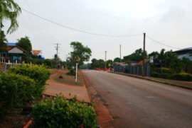
 Main street of Bamaga | |||||||||||||||
| Coordinates | 10°53′16″S 142°23′20″E / 10.8879°S 142.3888°E | ||||||||||||||
| Population | 1,186 (2021 census)[1] | ||||||||||||||
| • Density | 17.915/km2 (46.40/sq mi) | ||||||||||||||
| Postcode(s) | 4876 | ||||||||||||||
| Area | 66.2 km2 (25.6 sq mi) | ||||||||||||||
| Time zone | AEST (UTC+10:00) | ||||||||||||||
| LGA(s) | Northern Peninsula Area Region | ||||||||||||||
| State electorate(s) | Cook | ||||||||||||||
| Federal division(s) | Leichhardt | ||||||||||||||
| |||||||||||||||
Bamaga (English: /ˈbæməɡə/ BAM-ə-gə, Kalaw Lagaw Ya: [ˈbamaɡa])[2] is an Indigneous town and locality about 40 kilometres (25 mi) from the northern tip of Cape York in the north of Queensland, Australia. It is within the Northern Peninsula Area Region.[3][4] It is one of the northernmost settlements in continental Australia and is the administrative centre for the Northern Peninsula Area Regional Council.
In the 2021 census, the locality of Bamaga had a population of 1,186 people.[1]
- ^ a b Cite error: The named reference
Census2021was invoked but never defined (see the help page). - ^ Macquarie Dictionary, Fourth Edition (2005). Melbourne, The Macquarie Library Pty Ltd. ISBN 1-876429-14-3
- ^ "Bamaga – town in Northern Peninsula Area Region (entry 1447)". Queensland Place Names. Queensland Government. Retrieved 22 March 2014.
- ^ "Bamaga – locality in Northern Peninsula Area Region (entry 46103)". Queensland Place Names. Queensland Government. Retrieved 22 March 2014.
