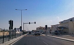
Bani Hajer
بني هاجر | |
|---|---|
District | |
 Al Shahama Street in Bani Hajer | |
| Coordinates: 25°14′12″N 51°24′19″E / 25.2367°N 51.4054°E | |
| Country | |
| Municipality | Al Rayyan |
| Zone | Zone 51 |
| District no. | 50 |
| Area | |
| • Total | 2.7 km2 (1.0 sq mi) |
| Elevation | 27 m (89 ft) |
Bani Hajer (Arabic: بني هاجر) is a district in Qatar, located in the municipality of Al Rayyan.[3][4]
In the 2015 census it was listed as a district of Zone 51, with a population of 56,027. It includes Izghawa, Gharrafat Al Rayyan, Al Gharrafa, Al Seej, Rawdat Egdaim and Al Themaid.[3]
The district is 10 km (6.2 mi) away from central Doha.[5] It is bordered to the north by Rawdat Egdaim.[4]
- ^ "District Area Map". Ministry of Development Planning and Statistics. Retrieved 12 February 2019.
- ^ "Bani Hajer, Zone 51, Qatar on the Elevation Map". elevationmap.net. Retrieved 3 January 2019.
- ^ a b "2015 population census" (PDF). Ministry of Development Planning and Statistics. Archived from the original (PDF) on 14 February 2017. Retrieved 1 January 2019.
- ^ a b "District map". The Centre for Geographic Information Systems of Qatar. Archived from the original on 24 November 2020. Retrieved 1 January 2019.
- ^ Cite error: The named reference
ashghal1was invoked but never defined (see the help page).


