This article needs additional citations for verification. (April 2012) |
Barauni | |
|---|---|
Town | |
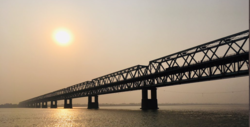
 Rajendra Setu, Barauni | |
| Coordinates: 25°27′58″N 85°59′13″E / 25.466°N 85.987°E | |
| Country | |
| State | |
| District | Begusarai |
| Region | Mithila |
| Government | |
| • Type | Nagar parishad |
| • Body | Barauni Nagar Parishad and Bihat Nagar Parishad |
| Area | |
| • Town | 50 km2 (20 sq mi) |
| • Urban | 150 km2 (60 sq mi) |
| Population | |
| • Urban | 150,000 |
| Language | |
| • Official | Hindi[1] |
| • Additional official | Urdu[1] |
| • Regional languages | Maithili[2] |
| Time zone | UTC+5:30 (IST) |
| Pincode(s) | 8511xx |
| STD Code(s) | 06279 |
| Vehicle registration | BR-09 |
| Lok Sabha constituencies | Begusarai (Lok Sabha constituency) |
| Vidhan Sabha constituencies | Teghra Assembly constituency |
Preview warning: Page using Template:Infobox settlement with unknown parameter "library"
Barauni is an industrial town situated on the bank of the river Ganges in the Begusarai district in the state of Bihar, India. It lies north of the Ganges (Ganga) River.
- ^ a b "52nd Report of the Commissioner for Linguistic Minorities in India" (PDF). nclm.nic.in. Ministry of Minority Affairs. Archived from the original (PDF) on 25 May 2017. Retrieved 22 January 2019.
- ^ "Archived copy" (PDF). Archived from the original (PDF) on 5 March 2016. Retrieved 14 May 2019.
{{cite web}}: CS1 maint: archived copy as title (link)
