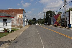
Barlow, Kentucky | |
|---|---|
 Barlow, Kentucky in 2017 | |
 Location of Barlow in Ballard County, Kentucky. | |
| Coordinates: 37°3′7″N 89°2′41″W / 37.05194°N 89.04472°W | |
| Country | United States |
| State | Kentucky |
| County | Ballard |
| Area | |
| • Total | 0.55 sq mi (1.43 km2) |
| • Land | 0.55 sq mi (1.43 km2) |
| • Water | 0.00 sq mi (0.00 km2) |
| Elevation | 374 ft (114 m) |
| Population (2020) | |
| • Total | 653 |
| • Density | 1,185.12/sq mi (457.81/km2) |
| Time zone | UTC-6 (Central (CST)) |
| • Summer (DST) | UTC-5 (CDT) |
| ZIP code | 42024 |
| Area codes | 270 & 364 |
| FIPS code | 21-03718 |
| GNIS feature ID | 0486360 |
Barlow is a home rule-class city in Ballard County, Kentucky, in the United States. The city was formally incorporated by the state assembly in 1872 as Barlow City and later reincorporated in 1903.[2] The population was 653 as of the 2020 census. It is part of the Paducah, KY-IL Metropolitan Statistical Area.
- ^ "2020 U.S. Gazetteer Files". United States Census Bureau. Retrieved March 18, 2022.
- ^ Commonwealth of Kentucky. Office of the Secretary of State. Land Office. "Barlow, Kentucky". Accessed 15 July 2013.