| Barnes | |
|---|---|
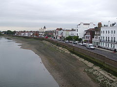
 The Terrace on Barnes riverside from Barnes Bridge | |
Location within Greater London | |
| Area | 4.50 km2 (1.74 sq mi) |
| Population | 21,218 (Barnes and Mortlake and Barnes Common wards 2011)[2] |
| • Density | 4,715/km2 (12,210/sq mi) |
| OS grid reference | TQ225765 |
| • Charing Cross | 5.8 mi (9.3 km) ENE |
| London borough | |
| Ceremonial county | Greater London |
| Region | |
| Country | England |
| Sovereign state | United Kingdom |
| Post town | LONDON |
| Postcode district | SW13 |
| Dialling code | 020 |
| Police | Metropolitan |
| Fire | London |
| Ambulance | London |
| UK Parliament | |
| London Assembly | |
Barnes (/bɑːrnz/) is a district in South West London, England, part of the London Borough of Richmond upon Thames. It takes up the extreme north-east of the borough, and as such is the closest part of the borough to central London. It is centred 5.8 miles (9.3 km) west south-west of Charing Cross in a bend of the River Thames.
Its built environment includes a wide variety of convenience and arts shopping on its high street and a high proportion of 18th- and 19th-century buildings in the streets near Barnes Pond. Together they make up the Barnes Village conservation area where, along with its west riverside, pictured, most of the mid-19th-century properties are concentrated. On the east riverside is the WWT London Wetland Centre adjoining Barn Elms playing fields.
Barnes has retained woodland on the "Barnes Trail", a short circular walk taking in the riverside, commercial streets and conservation area, including the Olympic Studios. The trail is marked by silver discs set in the ground and with QR-coded information on distinctive oar signs. The Thames Path National Trail provides a public promenade along the entire bend of the river which is on the Championship Course in rowing.
Barnes has two railway stations (Barnes and Barnes Bridge) and is served by bus routes towards central London and Richmond.
- ^ Census Information Scheme (2012). "2011 Census Ward Population figures for London". Greater London Authority. Retrieved 17 October 2023.
- ^ Key Statistics; Quick Statistics: Population Density [1] Office for National Statistics
