Barwon Highway | |
|---|---|
 | |
| Barwon Highway (green on black) | |
| General information | |
| Type | Highway |
| Length | 154.9 km (96 mi) |
| Route number(s) | |
| Major junctions | |
| West end | |
| East end | NSW/Qld Border |
| Location(s) | |
| Major settlements | Talwood, Bungunya |
| Highway system | |
| ---- | |
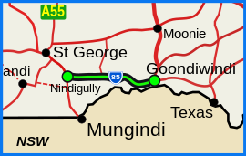
The Barwon Highway is one of the shorter state highways of Queensland, Australia, connecting the Goondiwindi Region and the Shire of Balonne. It starts at the Carnarvon Highway in Nindigully, 44 kilometres south of St George, and travels east for about 155 kilometres until it reaches Goondiwindi, where it terminates at the Leichhardt Highway.
The highway travels north of and roughly parallel to the Barwon River, after which it is named. The river forms part of the border between Queensland and New South Wales.