| Barwon | |
|---|---|
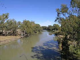
 Barwon River at Collarenebri | |
Location of Barwon River mouth in New South Wales | |
| Etymology | Aboriginal: from barwum or bawon, meaning great, wide, awful river of muddy water[1] |
| Location | |
| Country | Australia |
| States | Queensland, New South Wales |
| Region | South West Queensland, North West Slopes, Orana |
| Towns | Mungindi, Collarenebri, Brewarrina, |
| Physical characteristics | |
| Source | Macintyre River |
| • location | north of Mungindi, Southern Downs, Queensland |
| • elevation | 196 m (643 ft) |
| 2nd source | Weir River |
| Mouth | confluence with the Culgoa River to form the Darling River |
• location | east of Bourke, Orana region |
• coordinates | 29°57′29″S 146°18′28″E / 29.95806°S 146.30778°E |
• elevation | 110 m (360 ft) |
| Length | 700 km (430 mi) |
| Basin features | |
| River system | Murray–Darling basin |
| Tributaries | |
| • left | Gwydir River, Mehi River, Namoi River, Macquarie River, Bogan River |
| • right | Boomi River, Moonie River, Bokhara River |
| [3] | |
Barwon River, a perennial river that is part of the Murray–Darling basin, is located in the north-west slopes and Orana regions of New South Wales, Australia.
The name "barwon" is derived from the Australian Aboriginal words of barwum or bawon, meaning great, wide, awful river of muddy water; and also baawan, a Ngiyambaa name for both the Barwon and Darling rivers.[1] The history, culture and livelihoods of the local Aboriginal people are closely intertwined with the Barwon River and its associated tributaries and downstream flows.[4]
- ^ a b c "Barwon River". Geographical Names Register (GNR) of NSW. Geographical Names Board of New South Wales. Retrieved 11 January 2013.
- ^ "Fab Facts, Landforms, Australian Rivers". Geoscience Australia. Archived from the original on 29 July 2008. Retrieved 22 June 2008.
- ^ "Map of Barwon River". Bonzle.com. Retrieved 11 January 2013.
- ^ "Barwon–Darling". Explore the Basin: How the river runs. Murray–Darling Basin Authority. 2008. Archived from the original on 13 November 2012. Retrieved 11 January 2013.
