Nickname: Moresby Island | |
|---|---|
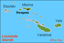
 Louisiade Archipelago, Basilaki on the top left. | |
Location within Papua New Guinea | |
| Geography | |
| Location | Oceania |
| Coordinates | 10°37′19″S 151°00′55″E / 10.62194°S 151.01528°E[1] |
| Archipelago | Louisiade Archipelago |
| Adjacent to | Solomon Sea |
| Total islands | 1 |
| Major islands |
|
| Area | 106 km2 (41 sq mi) |
| Length | 17 km (10.6 mi) |
| Width | 10 km (6 mi) |
| Coastline | 87.6 km (54.43 mi) |
| Highest elevation | 531 m (1742 ft) |
| Highest point | Mount Kova Sina |
| Administration | |
| Province | |
| Island Group | Samarai Islands |
| Island Group | Basilaki Islands |
| Ward | Split |
| Largest settlement | Yokowa (pop. 300) |
| Demographics | |
| Population | 1883 (2014) |
| Pop. density | 18/km2 (47/sq mi) |
| Ethnic groups | Papauans, Austronesians, Melanesians. |
| Additional information | |
| Time zone | |
| ISO code | PG-MBA |
| Official website | www |
Basilaki Island (Moresby Island[2]) is an island in the Louisiade Archipelago in Milne Bay Province, Papua New Guinea. It is located at the eastern end of the New Guinea mainland.
- ^ Prostar Sailing Directions 2004 New Guinea Enroute, p. 168
- ^ Admiralty hydrogr. dept (1879). "Moresby Island". The Australia directory. Vol.2. 2nd-6th ed. [With]. pp. 520–521.
