Basirhat | |
|---|---|
City | |
 City of Basirhat | |
| Coordinates: 22°39′26″N 88°53′39″E / 22.65722°N 88.89417°E | |
| Country | |
| State | West Bengal |
| District | North 24 Parganas |
| Government | |
| • Type | Municipality |
| • Body | Basirhat Municipality |
| • Municipality Chairman | Aditi Roychowdhury Mitra[1] |
| Area | |
| • Total | 22.50 km2 (8.69 sq mi) |
| Elevation | 6 m (20 ft) |
| Population (2011) | |
| • Total | 125,254 |
| • Density | 5,600/km2 (14,000/sq mi) |
| Languages | |
| • Official | Bengali, English |
| Time zone | UTC+5:30 (IST) |
| PIN | 743412 |
| Area code | 3217 |
| Vehicle registration | WB-21 |
| Lok Sabha constituency | Basirhat |
| Vidhan Sabha constituency | Basirhat Dakshin, Basirhat Uttar |
| Website | https://basirhatmunicipality.in |
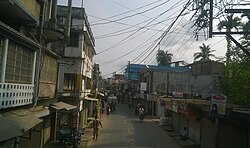
Basirhat is a city of West Bengal, India. It is located on the banks of the Ichamati (Ichhamati) River.
- ^ Official District Administration site Archived 20 August 2010 at the Wayback Machine
- ^ "Basirhat Municipality".

