Baso Liben | |
|---|---|
 | |
| Zone | Misraq Gojjam |
| Region | Amhara Region |
| Area | |
| • Total | 1,118.56 km2 (431.88 sq mi) |
| Population (2012 est.) | |
| • Total | 149,937 [1] |

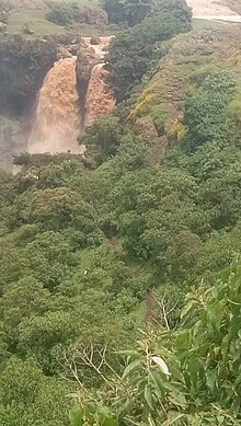
Baso Liben (Amharic: ባሶ ሊበን) is one of the woredas in the Amhara Region of Ethiopia. A triangular-shaped district at the southernmost point of the Misraq Gojjam Zone, Baso Liben is bordered on the south by a bend of the Blue Nile river which separates it from the Oromia Region, on the northwest by the Chamwaga river which separates it from Gozamn, and on the northeast by Aneded. The major town in Baso Liben is Yejube. there are two other small towns; Kork and Yelamgeji with significant trading activity
The woreda is surrounded by large gorges and lowlands of Abay river in the south and south east where significant investment is happening in sesame, mung bean and other cereals.
The woreda has small rivers Yada being the biggest, and the Sens which is a tributary of the Chamwaga. Several fords have been used since time immemorial to cross the Blue Nile from Baso Liben into the Guduru and Cheliya woredas in the Oromia Region, which are, in order flowing downriver: the Balanti, Malka, Malka Kuki, Malka Fursi, and Malka Yekatel.[2]
- ^ a b Geohive: Ethiopia Archived 2012-08-05 at the Wayback Machine
- ^ Cheesman, R. E. (April 1928). "The Upper Waters of the Blue Nile". The Geographical Journal. 71 (4): 358–374. doi:10.2307/1782413. JSTOR 1782413.
