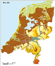
 The Netherlands c. 50 CE. The river islands, one of which was Batavia, can be seen slightly below the center. The modern Betuwe region corresponds greatly with the thin island that stretches from the country's centre to the German border, and has roughly a third of its western side brown (meaning fens) and two thirds of its eastern side green (meaning river valleys). | |
| Alternative name | Betuwe (modern region) |
|---|---|
| Location | Netherlands |
| Region | Gelderland |
| Type | Historical tribal land |
| Part of | Germania |
| History | |
| Cultures | Batavi |
| Satellite of | Roman Empire (after 80 CE) |
| Events | Batavian Revolt |
Betuwe (Dutch pronunciation: [ˈbeːtyu.ə] ), also known in English as Batavia (/bəˈteɪviə/ bə-TAY-vee-ə), is a historical and geographical region in the Netherlands, forming large fertile islands in the river delta formed by the waters of the Rhine (Dutch: Rijn) and Meuse (Dutch: Maas) rivers. During the Roman Empire, it was an important frontier region and source of imperial soldiers. Its name is possibly pre-Roman.
Administratively, the modern version, Betuwe, is a part of the modern province of Gelderland and although the rivers and provinces have changed over history it is roughly the same. Today it has the Waal river on the south and the Lek and Nederrijn in the north (all rivers which start in the delta itself and are branches of the Rhine or Maas). Historically, the former municipality of Rijnwaarden belonged to Betuwe, now in Zevenaar, which was cut off by the building of the Pannerdens Kanaal.
A major freight railroad, the Betuweroute, passes through the Betuwe. It was opened in 2007 after many years of controversy.

The Betuwe region is divided into nine municipalities: Lingewaard, Arnhem (southern part), Nijmegen (northern part), Overbetuwe, Neder-Betuwe, Buren, Tiel, Culemborg and West Betuwe. The region is characterised by its many orchards, and is for centuries known as the fruit garden of the Netherlands.[1]
- ^ Gelderland, Erfgoed. "Ontwikkeling van de fruitteelt in het rivierengebied". mijngelderland.nl (in Dutch). Retrieved 2024-07-08.


