| Baxter State Park | |
|---|---|
IUCN category V (protected landscape/seascape) | |
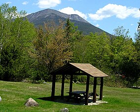
 Katahdin rises above Katahdin Stream Campground in Baxter State Park. | |
| Location | Piscataquis County, Maine, United States |
| Nearest city | Millinocket |
| Coordinates | 46°2′N 68°56′W / 46.033°N 68.933°W |
| Area | 209,501 acres (847.82 km2) |
| Established | March 3, 1931 |
| Visitors | 67,774 (in 2018) |
| Governing body | Baxter State Park Authority |
Baxter State Park is a large wilderness area permanently preserved as a state park in Northeast Piscataquis, Piscataquis County in north-central Maine, United States. It is in the North Maine Woods region and borders the Katahdin Woods and Waters National Monument on the east.
The park was established by 28 donations of land, in trust, from park donor Percival P. Baxter between the years of 1931 and 1962, eventually creating a park of over 200,000 acres (809 km2) in size. Baxter Park is not part of the Maine State Park system. Sole governance is provided by the Baxter State Park Authority, consisting of the Maine Attorney General, the Maine Commissioner of Inland Fisheries and Wildlife, and the Director of the Maine Forest Service. The park is independently funded through a combination of revenues from trusts, user fees, and the sale of forest products from the park's Scientific Forest Management Area. The park is home to the state's highest peak, Mount Katahdin. The number of visitors to the park declined from 75,000 in 2000 to 55,000 in 2005,[1] but since 2005 visitor use has been slowly increasing. In 2018, the gate counts were 67,774.[2]
- ^ Jermanok, Stephen (September 24, 2006). "Delicate Terrain". The Boston Globe Magazine. Retrieved September 24, 2006.
- ^ "2018 Annual Report.pdf". Retrieved May 19, 2020 – via Google Docs.
