Bayt Jiz
بيت جيز Beit Jiz | |
|---|---|
 The old school of Bayt Jiz | |
| Etymology: The ruin of the house of the valley side[1] | |
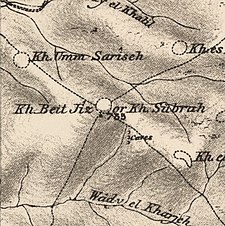
A series of historical maps of the area around Bayt Jiz (click the buttons) | |
Location within Mandatory Palestine | |
| Coordinates: 31°48′46″N 34°57′15″E / 31.81278°N 34.95417°E | |
| Palestine grid | 145/135 |
| Geopolitical entity | Mandatory Palestine |
| Subdistrict | Ramle |
| Date of depopulation | 20 April 1948[4] |
| Area | |
| • Total | 8,357 dunams (8.357 km2 or 3.227 sq mi) |
| Population (1945) | |
| • Total | 550[2][3] |
| Cause(s) of depopulation | Military assault by Yishuv forces |
| Current Localities | Har'el,[5][6] Tzelafon,[6] Gizo[6] |
Bayt Jiz (Arabic: بيت جيز) was a Palestinian Arab village situated on undulating land in the western foothills of the Jerusalem heights, 15 kilometers (9.3 mi) southwest of Ramla. In 1945, it had a population of 550. It was occupied by Israeli forces in the 1948 Arab–Israeli War and became depopulated.[7]
- ^ Palmer, 1881, p. 301
- ^ Village Statistics, Government of Palestine. 1945, p. 29
- ^ a b Village Statistics, Government of Palestine. 1945. Quoted in Hadawi, 1970, p. 66
- ^ According to Morris, 2004, p. xx, village #328 Also gives the cause for depopulation
- ^ Morris, 2004, p. xxi: settlement #33, October 1948.
- ^ a b c Khalidi, 1992, p. 365
- ^ Cite error: The named reference
Khalidiwas invoked but never defined (see the help page).


